


Kent’s Road of Remembrance in Folkestone is the subject of a ground investigation and remediation project following two landslips since January this year, with the work focusing on the geotechnical status of the area and the action required to safeguard this important historical site.
Kent County Council has instructed CAN Geotechnical to act as principal contractor and to carry out the ground investigation project.
Kent County Council Strategic Asset Manager Alan Casson said: “The Road of Remembrance is of significant importance to people living in, working in and visiting Folkestone, not only for travelling along but also for its historical significance.
“Kent County Council is pleased to be working with CAN again following other successful projects in the county. This is a substantial, technical, and very complex project, and we have made significant progress working with CAN, their specialist teams, and their supply chain partners. The detailed investigations they have been undertaking will inform the final design for stabilising the embankment and preventing future deterioration.
“We are grateful to everyone involved in the project, and especially to Folkestone residents and businesses for their continued patience as we work to make sure the embankment is safe for the future.”
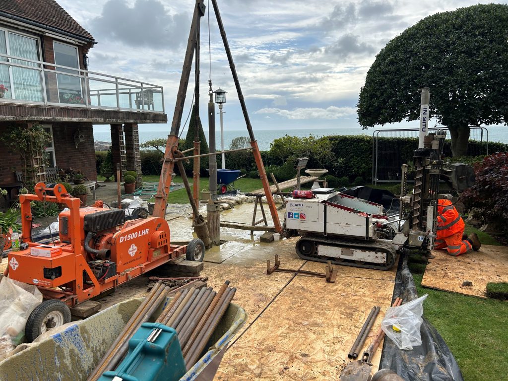
CAN Geotechnical Project Manager Andy Pope said the initial investigation work would inform the geotechnical design of the remediation works to follow. This initial work was carried out as part of a three-week programme that started on 9 September and was completed on time on 27September. The CAN Geotechnical design team is now collating all site-specific data from the initial ground investigation works, with this underpinning a geotechnical design to remediate the area following the recent landslips.
Andy said: “Mapping and surveying work has been carried out to the toe of the failure on the Road of Remembrance, combined with intrusive works (effectively boring to a depth of 25 m and carrying out cone penetrating testing) at the crest, to two locations on The Bayle and two residential properties located within Priory Gardens. We had up to 12 ground investigation specialists on site at any one time, all working together to obtain the required information for the ultimate design for the remediation works. The area under investigation is approximately 80 m in length and 40 m high and comprises sand, clay, sandstone and bedrock.”
He said that the team made use of a 13-tonne cone penetrating testing rig and a 5 m cable percussive borehole rig on the roads and brought in smaller 1.5-tonne and 3 m rigs for the work in residential gardens.
“By coring boreholes at a depth of 25 m and removing casings at approximately 1 m deep increments, we were able to record ground conditions at various depths. This enabled us to build an accurate impression of ground conditions. Cone penetrating testing enables us to gather detailed information on the soil type and stratification in addition to the strength of the clays and the relative density and friction angles in the sand.”
Andy explained that the team was very much aware that the Road of Remembrance is a very significant landmark in Folkestone. The road was renamed the Road of Remembrance after the end of the First World War to commemorate the journey taken by thousands of men on their way to war.
Andy added: “The road is lined with plaques and poppies for the annual Remembrance Day parade but because of the landslips, it has been closed for nearly a year. Unfortunately, the parade will not be happening again this year but we are working hard to understand the geotechnical issues that have created the landslips so that the area can be safely and confidently returned to the community.
“Owing to the very sensitive and high-profile nature of these works, the entire project team invested in developing strong relationships, working with residents and businesses. We are really proud to have been able to work closely with the community on this project.”
He said that the geotechnical design was being carried out by the CAN Geotechnical engineering division in collaboration with a number of RSK Group companies. These include:
- RSK Biocensus – preliminary ecological assessment
- RSK Geosciences & Geospatial – mapping of the Second World War bunker located on the Road of Remembrance and a cellar within one of the residential properties
- RSK Geophysics & SafeGround – PAS 128 survey and ground penetrating radar (GPR) surveys (non-intrusive ground surveys to identify buried underground services)
- CAN Geotechnical engineering division – inspection of the failed face
- RSK Geophysics – multi-analysis surface waves and electronic resistivity tomography surveys of the face of the failure
- RSK Ordnance Management – standard ground investigation review associated with areas on the flight path into London, while supplying the necessary supervision required for boring and cone penetrating testing work
- Central Alliance – cable percussive boreholes and cone penetrating testing
- Leap Environmental – supervision and logging of the cable percussive boreholes and cone penetrating testing works.
Building, Design & Construction Magazine | The Choice of Industry Professionals